Saturday, November 29, 2008
Rocky Mountain High: Scenes from Central Colorado
Denver may be the Mile High City, but Leadville – elevation 10,200 feet – is nearly two times higher and also holds a distinction as the loftiest incorporated city in the United States. Approximately 2700 hearty souls call this historic mining town home.
Notable among the countless architectural gems in Leadville is the Delaware Block Building constructed in 1886. This solid reminder of the Victorian era houses the Delaware Hotel today.
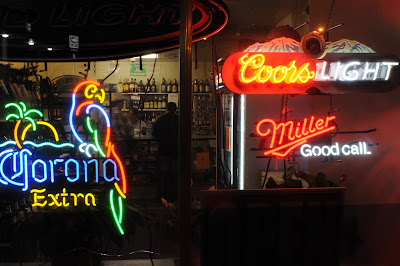
A storefront window at the Manhattan Bar advertises its status as a high altitude thirst center at 10,152 feet. In a place of extremes where no establishment wishes to be second best, more than one watering hole in Leadville claims to be the highest in the country.
Colorado State Highway 82 soars to 12,095 feet at Independence Pass to surmount the Continental Divide and the jagged Sawatch Range. After making the dizzying ascent from Aspen, a motorcyclist allows his engine to cool at the summit while taking in crisp air and majestic views above the tree line.
For more than a century, railroad passengers have embarked from the Denver & Rio Grande Western’s handsome Romanesque Revival depot at Glenwood Springs in search of mountain vistas, hot springs, backcountry adventure, and skiing. Today, Amtrak’s California Zephyr - operating between Chicago, Illinois, and San Francisco, California, via Denver - serves the town daily.
The Hot Springs Pool and bathhouse at Glenwood Springs has been a therapeutic destination since 1888. The pool’s temperature hovers around 90 degrees and is fed by local mineral-rich hot springs.
The 14.9-mile-long Colorado State Highway 5 – a component of the longer Mt. Evans Byway - holds a distinction as the highest paved road in the United States. Completed in 1930, the serpentine two-lane pike terminates in the summit parking lot at 14,130 feet in elevation, where a sign warns visitors about altitude sickness. Unparalleled, on-top-of-the-world views of the Front Range and its many escarpments - including Longs Peak to the north and Pikes Peak to the south - can be seen from here or via a short hike to the peak at 14,264 feet.
Sightings of Rocky Mountain Big Horn Sheep (pictured above), mountain goats, deer, elk, and marmots are frequent. Animals often catch the attention of visitors and occasionally disrupt traffic, too.
Unpredictable and inclement weather closes the road from Labor Day to Memorial Day. In higher elevations, the road is susceptible to buckling, as is evidenced above.
The eclectic Woody Creek Tavern lends its name from the small community in which it is located and was once a haunt for deceased gonzo journalist and known troublemaker Hunter S. Thompson. His rustic Owl Farm compound is mere minutes away.
Brewed in Golden for 135 years, Coors Beer is synonymous with the Rocky Mountains and the state of Colorado. Once available in only 11 Western states, Coors’ legendary commodity remained a product of mystique for those in the Midwest and East for generations. The brewery tour is a rite of passage for Coors aficionados and allows glimpses of the brew kettles.
Wednesday, November 26, 2008
New San Francisco Bay Area Related Blogspot Launched to Supplement The Journalist-Citizen
Happy Holidays from the City by the Bay! Please pardon the dust while I assemble a supplemental blog dedicated exclusively to the people, places, politics, culture, and history of the greater San Francisco Bay Area: The City ... of San Francisco (www.cityofsanfrancisco.blogspot.com). All San Francisco related content from The Journalist-Citizen was transferred to the new site today. Please check it out.
As it has since its July inception, the flagship Journalist-Citizen site will continue as a platform for sharing vignettes and images related to my travels, observations, and search for far-flung locales and forgotten heroes across the country.
I remain grateful for the high level of support and interest in both blogspots! And, as always, please feel free to share your comments and suggestions with me via e-mail at cjgoepel@gmail.com.
Cheers ... Christian Goepel
Thursday, October 16, 2008
Far from Santa Fe, Taos, and Albuquerque: The Plains of Easternmost New Mexico
Taken near Nara Visa, the photograph above does not capture the characteristic New Mexico mountain and desert scenery immortalized in travel guides and postcards, but so it is in the column of five counties – Union, Quay, Curry, Roosevelt, and Lea, from north to south – defining the Land of Enchantment’s eastern boundary with Texas and Oklahoma. Of this gritty and sparsely populated high elevation desert expanse known mostly for ranching, oil extraction, and limited agriculture, one could make the argument that yucca plants outnumber people by a million to one or more.
An important barometer in this arid territory, a rain gauge is attached to a fence cobbled together with barbed wire and secondhand railroad ties on a Quay County ranch. Much to the chagrin of those who make a living off the land, the approaching storm system will do little more than sprinkle a few warm drops on the parched earth. Hearty vegetation – including grasses and sagebrush – have adapted well to the lack of water.
This mural will have the casual observer believe that Tucumcari is the place where the camera-toting tourist meets the cowboys of the West. With a population of 5989 (2000 census), it is the only city of consequential size between Albuquerque, New Mexico, and Amarillo, Texas.
In a business district plagued with vacant store fronts, a piano advertising Danford Dan’s Music Shop is a welcome sign of life in Tucumcari.
Hours of canteen operation are appropriately listed in military time at the alleyway entrance to Tucumcari’s VFW Post 2528.
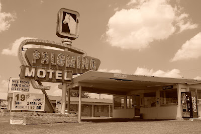
The Palomino in Tucumcari is the consummate timeworn motel found along oft-romanticized US Highway 66. The weekly rate of $90 at the Palomino is less than one would expect to pay for a single night in a hotel in large cities like San Francisco, Chicago, and New York. At one time, billboards exclaiming Tucumcari Tonite lined the highway and boasted the town’s 2000 rooms.
This mural provides a much-needed sense of optimism to Tucumcari’s declining business district.
The seat of Quay County, Tucumcari has been an important transportation crossroads in New Mexico for over a century. US Highways 54 and 66 intersect here (the latter pike was decommissioned and replaced with Interstate 40 more than a generation ago), as did mainlines of the Chicago, Rock Island & Pacific and Southern Pacific railroads. Thanks to abandonments and mergers in the last 30 years, Union Pacific is the only railroad in town today. Freight trains simply barrel through, intent on reaching cities, manufacturing centers, and ports elsewhere. And 40 years have passed since the crack Golden State streamliner whisking passengers between Chicago, Illinois, and Los Angeles, California, called on Tucumcari. An attractive, but disused stucco depot and a wide swath of land where the yards used to be is all that remains of railroading’s past.
In addition to holding a distinction as the largest and most prosperous community in easternmost New Mexico – 42,213 as of the 2007 census – Clovis remains an active railroad hub. Mainlines of the Burlington Northern Santa Fe fan out to the Midwest, Texas, and California from here. The classic neon sign above reminds railroaders to work safely.
Owing to its temperate climate, location on the western fringe of the Llano Estacado, and proximity to the Ogallala Aquifer, Clovis is the heart of a vast agricultural region. It is also the home of Cannon Air Force Base.
Highway signs at Texico beckon the traveler to choose an adventure westward, New Mexico style. Drivers bound for Santa Fe and Albuquerque will opt for US 84; those heading to Roswell or Las Cruces will rely on US 70. Missing population centers entirely, US 60 wanders across the state from east to west and divides it more or less in two.
A Clayton liquor store is abuzz with activity after the sun goes down. Town residents and area ranchers filter through, assuring brisk business for this small-town, family operated concern.
Nearby Clayton Lake State Park features fossilized dinosaur tracks. The Rabbit Ear Mountains visible to the north are a well-known landmark along the Cimarron Route of the precarious, 19th century Santa Fe Trail.
Giant ants scurry around the entrance to their colony in the rocky soil along US Highway 54 between Logan and Nara Visa.
The last rays of warm afternoon sun bathe the massive Golden West Flour elevator at Texico.
Thursday, October 9, 2008
One Afternoon in Downtown Dallas, Texas
This year marks the 45th anniversary of the assassination of President John F. Kennedy. Even today, X-marks the spot on Elm Street where the chief executive took that fatal shot to the head on November 22, 1963. Alleged assassin Lee Harvey Oswald is said to have fired upon the president’s motorcade from an open window on the sixth floor of the imposing Texas School Book Depository building in the background. Dealey Plaza’s Grassy Knoll is at left, while the Triple Underpass is out of view behind the photographer.
Sassy Sonya Schrader steals some of her husband Jeremy’s french fries at the Founders Grill restaurant in the Hotel Lawrence on Houston Street.
A manhole cover on Houston Street near Union Station provides access to the city’s water system.
Images: Panhandle and Llano Estacado of Texas
The gunslinging lawlessness of the West lingers: Wayward bullets pierced and pocked a historical marker near the Canadian River crossing on US Highway 287 south of Masterson.
In a scene reminiscent of the Dust Bowl, a fire burns on the wind-swept plains of Carson County, north of Washburn.
Equal parts kitschy and touristy, the Big Texan Steak Ranch in Amarillo stands as an allegory for Texan culture. Billboards advertising its existence line the highways radiating out of the Panhandle’s largest city for miles. Its menu caters to the carnivorous and even offers such Western delicacies as fried rattlesnake and Rocky Mountain oysters.
In the photo above, two brave souls face the restaurant’s ultimate challenge: Down a 72 oz. top sirloin steak, complete with all the trimmings – including baked potato, dinner roll, salad, and shrimp cocktail - in an hour or less and its free. Those who fail must swallow their pride and cough up $72.
According to the restaurant’s web site, 8500 folks have succeeded since the first 4.5lb. cut was served in 1960. Record holder Joey Chestnut scarfed it all down in an astonishing 8 minutes and 52 seconds.
Entrees galore pour out of the Big Texan’s kitchen during the hectic dinnertime rush.
Created by Ant Farm and sponsored by local philanthropist Stanley Marsh 3, the Cadillac Ranch exhibit west of Amarillo has given curious travelers a reason to get off Interstate 40 and stretch their legs for a generation. The ten vintage Cadillacs buried in a field within sight of historic US Route 66 embody one of the most remarked roadside attractions in the U.S. Visitors are numerous and graffiti is encouraged.
Amazingly enough, a tire on one of the Cadillacs still spins. This artistic monument to motordom is repainted so often that it can take on an entirely different appearance in a short amount of time.
Not surprisingly, rodeo is the official state sport of Texas. Pictured is the front gate to the Muleshoe Roping Club’s Dusty Rhodes Arena at Muleshoe.
A weekend rodeo in Muleshoe attracts competitors and spectators from all corners of the Panhandle and Llano Estacado. Pictured above, cowboys and cowgirls await their turn and watch the roping skills of the competition from afar.
Littlefield, population 6507 (2000 census), is the seat of rural Lamb County, the center of a major cotton producing region in the Llano Estacado, and the hometown of country music singer Waylon Jennings.
The deserted Atchison, Topeka & Santa Fe Railway depot at Chillicothe succumbs to neglect, weathering, and vandalism and faces an uncertain future.
The roadside Medicine Mound Depot Restaurant at Quanah offers patrons the opportunity to experience small-town Texas hospitality, relax in air conditioned comfort, and throw peanut shells on the floor.
Lubbock – metropolis of Llano Estacado territory – boasts a museum dedicated to the memory of one of its native sons, rock and roll musician Buddy Holly.
An iconic Phillips 66 gas station shield basks in the morning sun at Farwell.
The most obvious symbol of the Lone Star state flaps in a stiff wind at dusk in Amarillo.
Saturday, September 13, 2008
The Mile High City's Notorious Avenue: East Colfax
Denver, Colorado: August 25-28, 2008
A key component of transcontinental US Highway 40, East Colfax Avenue was the main thoroughfare into urban Denver and suburban Aurora from the east until supplanted by parallel Interstate 70 four decades ago. Once bypassed, this historic avenue declined precipitously, earned a sordid reputation, and fell victim to years of unchecked urban decay. Concerted renewal efforts on East Colfax in recent years have been mildly effective, yet crime lingers and the avenue finds it difficult to shed its rough-and-tumble status. Traces of prostitution, the drug trade, homelessness, vandalism, and theft are blatant enough to grab the attention of the casual observer.
What stands astride the avenue today provides an intriguing dichotomy. Timeless greasy spoon diners and dive bars coexist side by side with their newer haute and trendy counterparts. Generations-old mom-and-pop stores and motels labor on, sometimes under different ownership. Aged neon signs buzz overhead, cast colorful swaths, and hold steadfast as reminders of a halcyon era.
Below, photographic tribute is paid a handful of the iconic East Colfax hold-outs and throwbacks, still catering to the public, much as they have in one way or another for time immemorial.
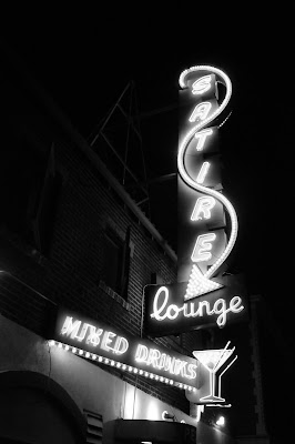
Complete with cheap beer, sticky floors, dim lighting, timeworn barstool upholstery, and Mexican fare, the Satire Lounge embodies the quintessential East Colfax speakeasy. Address: 1920 East Colfax, Denver.
Reminiscent of a small-town shop and known for its Schwinn affinity, family-owned and operated Collins’ Bicycles has served Denver since 1934. Address: 3217 East Colfax, Denver.
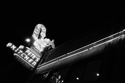
A community institution since 1942 and a popular destination for chow after the bars close, Pete’s Kitchen serves up three squares, 24 hours a day, seven days a week. Owner Pete Contos operates four other restaurants on the avenue. Address: 1962 East Colfax, Denver.
Opened as the Thompson in 1913 and renamed the Bluebird in 1922, this landmark theater is a vintage movie house turned popular concert venue. Address: 3317 East Colfax Avenue, Denver.
The Carriage Motor Inn appears to be the typical motel of old, save for one glaring difference: The presence of a high security fence separating the property from the street. Address: 9201 East Colfax, Aurora.
Subscribe to:
Posts (Atom)